
All Pictures are at the bottom of this post!
Here I am on a plane heading to Santiago, Chile, and then onto San Pedro. Why Chile, you ask? Since I left Botswana, Africa (3 years ago) in search of a new home. I have been asking visitors to my website www.LifeOfDug.com to decided where I should go in search of the perfect place to called home.
 This year, 2015, it was decided I should visit Chile and Madagascar. With Madagascar in the middle of both monsoon season and a plague, I decided Chile would be my first stop. I will visit Madagascar later in the year, once monsoon season passes.
To my surprise (not so much) Margarite decided to join me in this adventure. Luckily my free business class strategy worked. Not only business class, but lie flat beds. Our flight departs at 9:00 PM and lands at 7:00 AM a good night sleep should be invaluable.
This is not my first time to South America, back in 2005 I spent some time in Peru just north of Chile. Chile is sandwiched, between the Pacific Ocean and the base of the Andes. The Andes are one of world's great mountain ranges, Chile boasts some of the world's most varied and dramatic landscapes. To comprehend its diverse geography, imagine a single country stretching from Baja California through California, the Pacific north-west, and up to the Alaska Panhandle. Chile's length—including the entire length of its jagged coast and islands—is an amazing 7,633 miles in all, making it the 19th-longest country in the world when measured by coastline, and the second-longest in South America.
If you are already bored you can watch the video instead I like to call it 30 days in Chile in under 15 minutes.
Modern Chile reflects Spanish, Basque, British, German and Croatian ancestry, but the bulk of the population is Mestizo. Even so, there are still a million indigenous Mapuche in the south, a nation that remained autonomous until the late 19th century.
With Chile being so long I had no idea where to go first? I decided I would travel from north to south.
I need to give a shout out to Jennifer Gillmore of Travel Beyond her insight in helping me plan this trip was fantastic, I could not have done it without her.
First stop San Pedro. San Pedro, Chile, is a charming colonial village, with a large central square, the 18th-century adobe San Pedro Church, and streets lined with low-rise shops, restaurants and small hotels and hostels. Barely an hour southeast of Calama and 1,040 miles north of Santiago, San Pedro is at an elevation of 8,100 feet. The main attraction here is R.P. Gustavo Le Paige Museum, which exhibits pre-Columbian mummies and other artifacts unearthed by a Jesuit priest who was also a noteworthy archaeologist.
We arrived in Santiago to a bit of a problem. I had a great night sleep but when the flight attendant
 woke me, she had our original boarding passes in hand. She was not happy and said a gate agent would be meeting us when we land. How to get out of this mess? The only thing I could think of, was one time I ate at a restaurant and had forgotten my wallet, at least that is what I told them. The owner let me wash dishes to pay off the meal.
You will never believe this! (See picture) Yep, the gate agent let me work off the business class fare. I managed the queue for domestic check in. Four hours of work and they called it even.
While I was working Margarite decided to check our bags to Calama. We NEVER check bags because of the hassle if our luggage gets lost. Margarite thought, it is a short flight with no connections, what could happen.
As we approach security, Margarite turn white as a ghost, I thought she was going to faint. Maragrite had left all her papers and money in the luggage she had checked. How do we get past security, with no identification? I gave Margarite my LAN airlines flight credentials. The ones I got for the four ours of work I had done. I said, walk through the airport security section for employees. Hold up my credentials but put your fingers over my picture and name. Walk quickly in a crowd and act like you own the place. It worked like a charm!
I arranged to stay at a resort called Tierra Atacama, a few years back a fairly good poker player had lost some money to me that he could not repay (or did not want to). He told me he owned a resort in San Pedro, Chile, and if I was ever there, he would take care of the bill. Payback time!
 We were greeted at the airport by our driver, he did not speak a lick of English and my Spanish was a little rusty, but came back fairly fast. The drive to San Pedro was an hour, and uneventful, we arrived at Tierra Atacama at 2:00 PM, 24 hours of traveling. Tierra Atacama was a mile outside of San Pedro. My first impression was Canyon Ranch in Chile. Canyon Ranch is where Chephart Yosh lives in Tucson, AZ. Tierra Atacama is a very exclusive spa / health oriented resort. Our guide greeted us with a fantastic lunch and helped us plan out our stay.
 Here is what we decided to do:
Afternoon of our arrival - Atacama Salt Flat (Chaxa Lagoon & Flamingo Reserve)
Day 1
Morning - Guatin / Puritama (hike)
Afternoon - Quebrada Del Diablo (mountain bike)
Day 2
Morning - Mirador del Viento (mountain bike)
Afternoon - Guatin - Gatchi (hike)
Evening - Star Gazing
Day 3
Full Day - Tataio Geysers (4 wheel drive)
Here is what we decided to do:
Afternoon of our arrival - Atacama Salt Flat (Chaxa Lagoon & Flamingo Reserve)
Day 1
Morning - Guatin / Puritama (hike)
Afternoon - Quebrada Del Diablo (mountain bike)
Day 2
Morning - Mirador del Viento (mountain bike)
Afternoon - Guatin - Gatchi (hike)
Evening - Star Gazing
Day 3
Full Day - Tataio Geysers (4 wheel drive)
We also fit is a self guided walking tour of San Pedro. The museum's mummies are quite a sight—some are displayed in glass cases, others in earthen jars, and most still have their skin, eyelashes and thick brown hair. San Pedro also has one of Chile's landmark colonial churches and several nearby archaeological sites, including the restored fortress of Pukara Quitor.
 After Lunch we headed out on our excursion - Atacama Salt Flat (Chaxa Lagoon & Flamingo
Reserve) The journey starts with a brief visit to Toconao village where the square and the historic church are the main attractions. We also visited a local family who lives off the sales of their handcrafts. After Toconao we continue to the National Flamingo Reserve in the Atacama Salt Flat. There are three types of flamingo to be found here, living off the microscopic lagoon life. The views of the Andes as the sun sets are truly amazing.
This excursion well worth the price, we have seen flamingos in Tanzania though once you have seen one you have NOT seen them all. The Chilean flamingos have black tipped wings that give them a unique color when they are not flying. The salt flats, are flat when you look at them from afar, but up close you see the surface is very bumpy and lumpy. The reason for this is the salt is brought up from
 below when the water table raises. The water then evaporates leaving the salt and minerals as a lumpy deposit.
Our guide Leo was very informative and set up a nice snack of fruit, cheese, and crackers for us to enjoy as we watched the sun go down.
Dinner was served at 9:30 PM when we returned. The food has been excellent.
Off to bed as this will be our first sleep in 35 hours.
Day 1 (full day)
After breakfast we met our guide her name is Karenze our hike is titled - Guatin / Puritama it is scheduled for 2.5 to 3.5 hours, this includes a one hour drive to the start of the hike, we thought we would start out with a medium hike as we are at 8,000 feet and will be hiking to a little over 13,000 feet.
 This excursion is better done in the morning because of the temperature changes. The walk starts at an altitude of 2,800m/9,186 ft to the northeast of San Pedro. The walk is a steady uphill climb, through the valley which is scattered with igneous rocks from the volcanic explosions of the past. We eventually arrive at the Puritama Thermal Springs, 8 pools of limpid warm water where soaked ourselves and relaxed before returning to the hotel.
The valley we are exploring is one of the driest places on earth, so it was very interesting to see this stream / river flowing through the canyon. We followed the paths carved in the canyon by the goats and sheep.
After about a hours hike we reached the source of the river which was a natural hot spring. What a great reward after a hot hike. Again we were served a nice snake where I indulged myself with a beer.
 On our return we had a great lunch which was a smoked salmon sandwich with avocado.
This afternoon, will be an easy mountain bike ride.
Devils Canyon / Catarpe - This is billed as a medium ride. Joining us is a couple from Brazil, Pedro and Medellin. We departed the hotel on bikes heading north towards the Salt Mountain Range, and beautiful Devil's Canyon. The ride takes place at an average elevation of 2,400m/8,000ft. After crossing the San Pedro River we arrive at the Canyon, which is flanked by clay cliffs and has a sandy bottom in places. The ride is a constant gentle climb until we come out of the labyrinth on to the Catarpe plateau. The return journey follows the natural course of the San Pedro River until we reached the village and hotel.
 The ride was fantastic just what we needed to stretch our legs. No issues with the altitude, the part through the narrow canyon was awesome with the trail narrowing to just a few feet in some places. As usually no ride is complete with out a good crash. There was a one foot drop that I planned to take, but others in front chose to stop. I forgot to unclip and went down hard. Only a bruised ego and elbow.
Here is a quick overview of the meals we are and will be enjoying. - Traditional Chilean food tends to be simple and hearty peasant fare, such as cazuela (a thin stew with potatoes, corn on the cob and either chicken or beef), empanadas de horno (baked meat pies, usually with ground beef), locro (a meat dish with potatoes and vegetables), charquican (a dish with vegetables and dried beef), humitas (similar to Mexican tamales) and pastel de choclo (a corn-based casserole with onions, hard-boiled eggs and beef or chicken, easily the best traditional meal).
Fish and seafood, though, are the highlights of Chilean cuisine. Try parrillada de mariscos, a mixed grill of seafood, but don't miss corvina (sea bass as its more commonly known trade name), congrio (conger eel), locos (abalone), centolla (king crab) and machas (razor clams). More adventurous diners can try less conventional shellfish such as the picoroco (giant barnacle) and erizo (sea urchin). On the island of Chiloe, the curanto, a massive combo of shellfish, seaweed, dumplings and meat, is legendary. In Patagonia, game dishes such as wild boar, guanaco and rhea (the latter two are now farmed in captivity) are becoming common menu items.
With vineyards ranging from Limari Valley in the north to the Maule and beyond in the south,
 Chilean wines are diverse, and many wineries are open for tours and tasting, though much of the best is for export only. The signature varietal is the red Carmenere, extinct in its native France but rediscovered in Chile in 1994.
Chile's national cocktail is the pisco sour, which blends the local grape brandy with sugar and lemon, then tops it with bitters. Other drink specialties include borgona, a red wine punch prepared with sparkling water and fruit, and cola de mono, a Christmas drink similar to eggnog. German settlers brought with them the tradition of brewing tasty beers, and the local chopp—draft lager—is excellent. In recent years, many new artisanal brews have appeared on the market.
Predominant Religions: Christian (Roman Catholic, Protestant); though many Mapuches and Aymaras communities are nominally Catholic, they practice their own religious beliefs.
Day 2
After a great nights sleep except for the few times the local dogs decided they should bark excessively. We met up with our guide for a more extreme mountain bike ride.
Windy Lookout Point / Moon Valley, the Dune - The description says 2 - 3.5 hours, level of difficulty
 is difficult. Depart from the hotel heading northeast then head north towards the Salt Mountain range enjoying marvelous views of the Andes and volcanoes. Continue along the cornices viewing the formations of Death Valley from above, before descending via the old trails into the valley itself. Once at the bottom, continue on to Death Valley and cycle through the amazing scenery before returning to the hotel. The uphill and downhill parts are steep in places and this excursion gives a great workout!
The ride started out similar to the ride the prior afternoon. It was just Margarite, our guide, and I. When we entered the canyon we went left, instead of the right, we took the afternoon before, that is where the similarities ended. The trail become a
 15% grade of lose gravel and sand. Almost immediately our lungs were on fire, we quickly geared down and found a rhythm. After what seemed like hours but was only 20 minutes, we reached the old tunnel. This was the original route between Calama and San Pedro. We went through the tunnel made a quick right and continued our climb, in many spots it was to steep to ride, so we carried our bikes. We had gone from 8,000 feet to over 12,000 in a fairly short period of time. Our guide was impressed!
Once we reached the top of the canyon we rode the rim, very beautiful yet at the same time stressful. One wrong move and you're doing a few thousand foot jump!
 Our guide decided to take us down the dry river bed. To quote "this is a place we do not take guest, but you two are strong" it was an awesome trail, though a bit to much sand for my liking.
At one point there was a 3 foot drop Margarite was in front and cleared no problem. I was not so fortunate, leaning to far forward my front wheel dropped and I went head over heals, my handle bars turned gouging me in the ribs, cracking a few. The good news, it only hurt when I took a breath, the bad news, I can not live without taking breaths.
I dusted myself off and we continued the ride, just fabulous.
Once back at the hotel we took a little break had lunch and then headed out on our afternoon hike.
Guatin / Gatchi - Level of Difficulty: Medium - Here is the description - depart the hotel in a vehicle towards Guatin Valley (2,800m/9,186ft). The confluence of two rivers takes place here; one coming
 from the warm thermal springs of Puritama, and the other is the Purifica River, whose waters are from the Andes Mountains. This unique mix of warm thermal spring water and cold clear mountain snowmelt gives rise to the new river which supports the unique ecosystem of the Guatin Canyon. We hiked alongside waterfalls and rocky climbs whilst marveling at the amazing Candelaria cactus.
This hike is to the west of the hike we had done the day before. At first I was a little concerned it looked like the hike was going to be a little boring and repetitive. Then we entered the canyon and everything changed. The walls of the canyon were much steeper in this section the vegetation much different and the hiking was more a combination of hiking and rock climbing. The hike was scheduled for two hours we covered it just over an hour. It was just Margarite, our guide and me.
Time for a shower and dinner.
Day 3
The dogs were more active last night so sleep was rather difficult. Wake came at 5:00 am as we are departing for the geysers at 5:30.
Today we will depart Atacama but before we do we will get one more excursion.
The Tatio Geisers - This is an easy excursion most of it is driving, it will take about 7 hours. Here is
 the description - Tatio Geisers are located at an altitude of 4300m /14,190 ft. The geothermal field has close links to the volcanic activity in the zone and consists of huge steam columns which reach heights of 12m / almost 40 ft. Breakfast is served as dawn breaks. On the way back to the village, there is the opportunity to spot families of vicuñas and if we are lucky, foxes, vizcachas and Andean ostrich. We stop in the hamlet of Machuca before returning to the hotel by vehicle.
The geysers were great to see, but no where near the level of Iceland. We saw lots of lama and other wild life. Actually lamas are not wild life they are domestic. The reason this trip is so early in the morning is to arrive at the geysers while the temperatures are still low -5 Celsius. This allowed us to see the steam coming from the geysers, as the day heats up the steam is not visible.

After a short walk through the geysers we had a nice breakfast. On the drive back we stopped at a small village to use the rest room and visit a church. After that one more stop at a lagoon where native ducks, geese and even some flamingos were hanging out.
Once back at the resort we packed for our next adventure, Easter Island. The best part we got dropped
back off at the Calama airport by our driver and never got a bill. Boy do I like poker!
Calama to Santiago, over night in Santiago before catching a 6 hour flight to Easter Island.
Our flight from Calama to Santiago ran like clock work. When I booked the flights to Easter island I booked it as a connection. Calama to Santiago - Santiago to Easter Island. I did not realize there was a 12 hour layover in Santiago. Now what.
I never really noticed this until now, but the only places you can get horizontal in airports are hard surfaces. Like cement floors. All the seats in the gate areas have dividers every few seats, they look like they are arm rest, but we found out they are to prevent people from sleeping (spending the night sleeping at the airport). Around mid-night a security guard told us we had to leave. He said the best place to go was the Holiday Inn right in front of the airport.
 We thought perfect! We could sleep in the lobby they should have comfy seats. This worked for about an hour. It was now 1:00 AM we still had 8 hours until our flight. The front desk clerk said we needed to leave or get a room. We made up story that our flight was canceled and our wallets were stolen. What a nice guy he checked us in at no charge. Gave us a small, but nice room that allowed us a few hours sleep, he even gave us a free breakfast.
Day 4
Easter Island - Culturally Polynesian, politically Chilean and semitropical in climate, Easter Island has much to offer the modern-day vacationer. The first inhabitants of Easter Island called it Te Pito o Te Henua (the Navel of the World). Visitors today often call it the world's largest open-air museum. The island, which is 60 sq mi/155 sq km, has a fascinating—and tragic—history.
Our flight was just over 5 hours, the time change was just 2 hours, based on longitude the time
 change should be 3 or 4 hours. To help with mainland commerce they keep the time differential close to the time in Santiago thus 2 hours.
We were greeted at the airport by Peter Naef. Peter is from Switzerland, growing up he played soccer eventually playing in the World Cup. He played professionally throughout Europe and coached in the United States. A adamant bachelor until age 50 when he met the love of his life Tiare. They decided to settle in Easter Island Tiare's home. They have an adorable daughter Annabel. We will be staying with Peter and his family on Easter Island. Peter with the help of his father in law and brother in law built three magnificent bungalows that sit along side their primary home.
On the drive from the airport to the bungalows Peter gave us a quick overview of the island and a quick tour of town Hanga Roa, the largest and really only town on the Island. The name on the bungalows are Hareswiss meaning Swiss House. The bungalow was perfect, from the porch we got a view of the sea, inside there was a sitting area / kitchen table, a kitchen section and a king size bed along with a twin bed. The bathroom was appointed nicely with great water pressure in the shower. All the windows had screens, so we could enjoy the nice sea breezes without the worry of bugs.

Sprawling and densely wooded Hanga Roa, the island's only town, is the site of the much-improved Father Sebastian Englert's Archaeological Museum. Nearby sites such as Ahu Tahai, the spectacular Rano Kau crater and its Orongo ceremonial village—site of the "birdman" cult that superseded the moai as objects of veneration—and Ahu Vaihu are all easily accessible from town. The highlight of any visit to Easter Island is the iconic moais, or mysterious stone monoliths, that have intrigued Western visitors for centuries. If it weren't for those strangely beautiful ruins—massive carvings of abstract human figures, toppled and abandoned long ago—few would likely venture here.
Once we were settled we walked to town, about a 25 minute walk, we took our time walking along the coast visiting our first moais or figures. We stopped at the bank to get some pesos. Most establishments took credit cards, but we wanted some cash just in case. We were both getting hungry so we picked a restaurant Te Moana along the water known for it's Ceviche, raw fish prepared in lime and or lemon juice.
 After a great meal we walked through town, picked up a few snacks and headed back to the bungalow. With the adjusted time zone sunrise was at 7:30 AM, but sunset would not be until close to 10:00 PM. We hit the sack early, we had, had two long days of touring and travel and wanted to be well rested for tomorrow.
Day 5
Today Peter will be giving us a private tour of the island. If you ever choose to visit Easter Island I highly recommend Peter as a guide. Two big reasons, his tours are private in our case just the two of us, at most 4 people, though Peter is Swiss he has been visiting or living on the island for
 over ten years, plus his wife's family are native to the island so his knowledge is vast and accurate.
We went for a short run along the coast to stretch our legs and then met up with Peter at 9:45 AM.
The main attraction or Easter Islands are the Moais. No one knows exactly the meaning of the Moais, and exactly how they moved the Moais from the quarries where they were carved to the coast where they were displayed, many time over 5 kilometers away, some weighing 5 tons or more. As we toured, we saw Moais in all different stages of life, from partially carved to fully restored.
 Rano Raraku quarry alone has nearly 400 moais. At the quarry, you can see moai in various stages of completion, from a rough outline in the ground to the nearly finished product (apparently the carvers simply laid down their tools one day, never to take them up again). We stopped at Anakena for a late lunch, Anakena is another site of moais and also a beautiful beach. It is all part of the national park system here on the island. We had some Ceviche at a little snack bar that was as good as any Ceviche we have had at fine restaurants.
Peter filled us full of interesting facts and legions about the island. After the tour I decided I had my own legion. Just like Machu Picchu, the Pyramids, Petra, the Moais were built by aliens.

Peter dropped us off in town so we could grab some dinner, another great restaurant at the end of the city dock, La Kaleta I had the short ribs, very good, and Margarite had grilled tuna. Also on the city dock is a Gelato shop, with Gelato as good as you get in Italy. We took a causal walk back to the bungalow for a quiet evening of sitting on the porch and reading.
Day 6
Peter gave us a ride into town where we rented two mountain bikes. Peter had given us a route that would cover the section of the island we had not covered the day before. First we biked from town to Orango which is a stone village and ceremonial centre. It is located on the southwestern tip of Easter Island. Built on the craters edge of Rano Kau Volcano, which is the tallest volcano on the island. The island is shaped like a triangle with three volcanoes at each point. Rano Kau which is the South East point Terevaka which is the Northern point and Poike which is the Western point. From the village Orango you could get a nice view of the island. You also got an understanding of the size of the volcanoes by seeing the size of the crater. There is a lot of history around Orango. This area at one time, worshipped the birdman.

From Orango we biked north seeing more moais. As we approached the north east coast we came across some of the volcanic tubes, often incorrectly called caves, where some hid during tribal wars; other tubes served as garden and orchard sites.
At this point the road was only passable via mountain bike or hiking. We continued along the coast returning to Hanga Roa. Peter had recommended a local fish restaurant for dinner and that is where we went. Another great meal at Tataku Vave. A true local place we did not see one tourist there. We returned the bikes, stopped for gelato and walked back to the bungalow for a relaxing evening sitting on the porch.
Day 7
Today we head to Santiago this will be our third time at the Santiago airport, but our first time staying
 in Santiago. We will be arriving at 8:00 PM. While visiting Santiago we have arranged stay at an apartment in the center of the city.
Santiago, like Chile in general, has enjoyed a renaissance of cultural, intellectual and especially commercial activity for more than two consecutive decades. The Andes Mountains overlook Santiago's eastern edge, and their snowy peaks provide good hiking, skiing, rafting and kayaking—and the beach is only a short drive away. Small wonder it is the country's capital and largest city, and one of the continent's largest metropolises.
Our apartment is located in the Bellas Artes district of Santiago about a 30 minute taxi from the airport.
Day 8
Our first full day in Santiago. We went for a short run along the river about 3 blocks from the hop on hop off bus to give us a quick overview and some history of the city.
 apartment. The apartment building has a market so grocery shopping is rather easy. After a quick clean up we headed out to figure the lay of the land. We decided to take the
Centro (downtown Santiago) is still dotted with Spanish colonial buildings and old churches, as well as many sparkling new modern buildings. Other neighborhoods house international restaurants, upscale boutiques and lively nightlife. Tourist areas are compact, and the resident Santiaguinos are pleasantly helpful. The city has a certain efficiency not found elsewhere in Latin America, and an obvious prosperous feel to it. The major drawback is that ongoing development and traffic congestion have created air pollution and smog, at first we thought it was overcast, but no it is smog.
After the bus tour we opted for lunch and then off to the market, not the grocery, but the La Vega market, we picked up some fresh fruit.
 We now had a good understanding and feel for Santiago.
Day 9
Today we will be taking a bike tour that will focus mainly on the street art and markets of Santiago. The company La Bicicleta Verde "The green bicycle" offers several bike tours, we opted for "local life and markets morning" it was a fantastic tour. What a great way to hear about the history and changes that have occurred in Santiago. Much of Santiago is covered with street art. Some might call this street art graffiti, but it is clearly art. We spent some time on the south side of Santiago which has become the trendy side. This is where most of the street art is. We visited a poets house by the name of Pablo Neruda who was also involved in politics. From there we visited La Vega which is one of the largest fruit and vegetable markets in the world. From La Vega we toured the downtown or northern side of the city. After the tour we returned to La Vega and had lunch with the locals, then walked the streets taking in all the street art, working hard to understand the meaning
 behind the art.
Before returning back to our apartment we decided to walk the hill of St Lucia just one block from our apartment, it was a magnificent hill, with a castle like structure and chapel at the top. This vantage point gave us unobstructed views of the city. It would soon be time to pick up our laundry so we headed back to the apartment, plus, tomorrow will be a long day.
Day 10
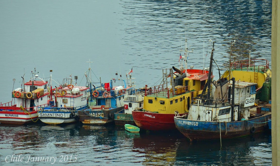
Today we will take a day trip to Valparaiso. Founded in 1536, the picturesque port city of Valparaiso, Chile, was named a UNESCO World Heritage site for its distinctively spontaneous hill neighborhoods and their vernacular architecture, including more than a dozen funicular cable cars that connect the port with its surrounding heights.
 Trains, Planes, and Automobiles, of should I say Subways, and Buses. We took the subway to the bus terminal. I have used subways all over the world and I need to give the Santiago Subway a big thumbs up. Clean, easy to use, and cheap, $650 peso, about $1.00 per ride. We took the subway from the St. Lucia station to the University of Santiago station. The University Station is where the bus terminal resides. We had little difficulty understanding the process up to this point. At the bus terminal we ran into an issue, it was not a language issue, but a logistics issue. We have now been in Chile for almost two weeks, so the rust is off our Spanish. Once we found our bus, the issue was where to buy tickets. Every ticket booth was closed. Yes it was early but the bus was leaving. We got on without a ticket. So far so good.
After about a 15 minute drive we pulled into another bus terminal, it looked identical to the first terminal, was it possible they knew we had no tickets and they were kicking us off the bus. Actually this was the terminal that you buy the tickets, about half the riders got off purchased tickets and got Pullman. We had heard good things about them. Our experience was great, clean, comfortable, and ran on time.
 right back on. We decided to use the bus company
We arrived at the Valparaiso at 9:00 AM just two and a half hours after departing our apartment and about $7.00 US dollars lighter. Not a bad way to travel.
To get to the historical section of Valparaiso it is a twenty minute walk through a section of town that many had advised us against walking through. It was 9:00 AM on a Tuesday morning what could happen. What a great walk through an industrial and distribution section of the city. We were glad we took the walk.
Valparaiso is built into the hills that rise out of the Pacific Ocean, in some respects it resembles San
 Francisco, California, just substitute the San Francisco cable cars for Valparaiso, Funiculars.
Once we reach the historic district we stopped at a lovely cafe La Panera the owner a young lady from Santiago who had recently spent time in the United State, Australia, and New Zealand spoke perfect English. We enjoyed some breakfast as well as pastries while she gave us a map and great suggestions on what to see during our visit to Valparaiso. If you are in Valparaiso please visit La Panera. We walked the streets taking in the city, hitting most of the terraced view points. Like the South Side of Santiago, Valparaiso had much street art. We visited the art museum and then took the long walk along the ridge to La Sebastiana, one of Pablo Neruda's many eclectically decorated homes, located high above the harbor. While in Santiago we were unable to go inside Pablo Neruda's home, here we could.
We learned a lot about Neruda's idiosyncrasies and obsessions. Guess this guy liked investing in real estate. Prior to the tour of the house we had lunch around the corner at Sello Verde. We had a pleasant lunch nothing special but it suited our needs. We sat on the front porch, there was also seating on an upstairs balcony with great views. Unfortunately for us, the balcony was full when we arrived.
We continued walking the streets, and taking in the sites. They have a saying in Valparaiso, "watch
 your feet or wash your feet". This same saying can go for Santiago. It seems they do not curb their dogs so you need to be very careful where you step.
It was nearing 5:00 PM and we had a few hour trip back to Santiago. We decided to walk back to the bus terminal. The city was alive the street markets, selling fruits and vegetables as well as crafts.
Our transport back to Santiago was as comfortable and uneventful as our morning ride.
Day 11
Today is our last day in Santiago we walked to the top of Funicular - Estación Pio Nono - Parque Metropolitano de Santiago, from the top we could see the entire city. We hiked up and took the funicular down.
 While visiting the statute of the Virgin Mary, which is at the top of the hill overlooking Santiago. We got a very interesting history lesson from a local tour guide. We learned that the Virgin Mary was not really a Virgin, but actually had slept around a bit on Joseph and ended up getting pregnant. She had no idea what to do. She loved Joseph and could not bare to break his heart. In a panic she created the story of carrying gods child. Once the baby was born and such a big deal was made about it, Mary could not tell the truth and Christianity was born. Not sure if this is a true story or folklore but that is the story the guide passed on.
After the walk we toured the city by foot. I like to collect bike jersey's so we walk across town to where the bike shops are. Yes a street with about a dozen bike shops.
Tomorrow morning we are off to the Lake District where we are staying on a Husky Farm.

Day 12
Early wake up call to catch a 9:30 AM flight to Temuco. We are heading to the Lake District of Chile. South East of Santiago a popular vacation spot for Chileans. The two towns we will be visiting are Villarrica and Pucon. Both towns are on Lake Vallarrica which is at the base on Villarrica Volcano.
The drive from Temuco to Vallarrica is about an hour, which is also the amount of time it took us to rent our car from Budget. Things are a little slower in South America then North America. South Americas definition of fast is much closer to Africa's definition. We arrived in Vallarrica around 1:00 PM just in time for lunch. We found a great place on the lake called Restaurant Brazas Vallarrica, I
 had the sea bass, Chilean Sea Bass of course and Margarite had the beautiful piece of filet mignon wrapped in bacon. We both, truly enjoyed our meals.
We had arranged to stay on a Husky Farm, what is a husky farm you might ask. Just as in Alaska, Greenland, southern Chile uses huskies to pull sleighs for transportation. These huskies need to be bred and trained, thus the husky farm. The farm we are staying on currently has 49 huskies in training. The farm is owned and operated by Inga and Konrad Schaab. We arrived at 4:30 PM as the huskies were going out on a training run. What a sight.
As I write this update I am on a flight from Temuco to Santiago. I lean over to Margarite who has the
 window seat and is to my left. I say, "You are lucky you are not me. I got stink man to my right and boy is he stinky!" Margarite leans toward me and says, "you are stink man!" I then realized I was smelling myself and sure enough I was stink man. Sure I have been showering everyday sometimes twice a day, but I have been wearing the same clothes for the last 4 days. This works well for my philosophy of traveling with one bag, but I am losing friends fast. I better either change my clothes or wash the ones I am wearing before another day goes by.
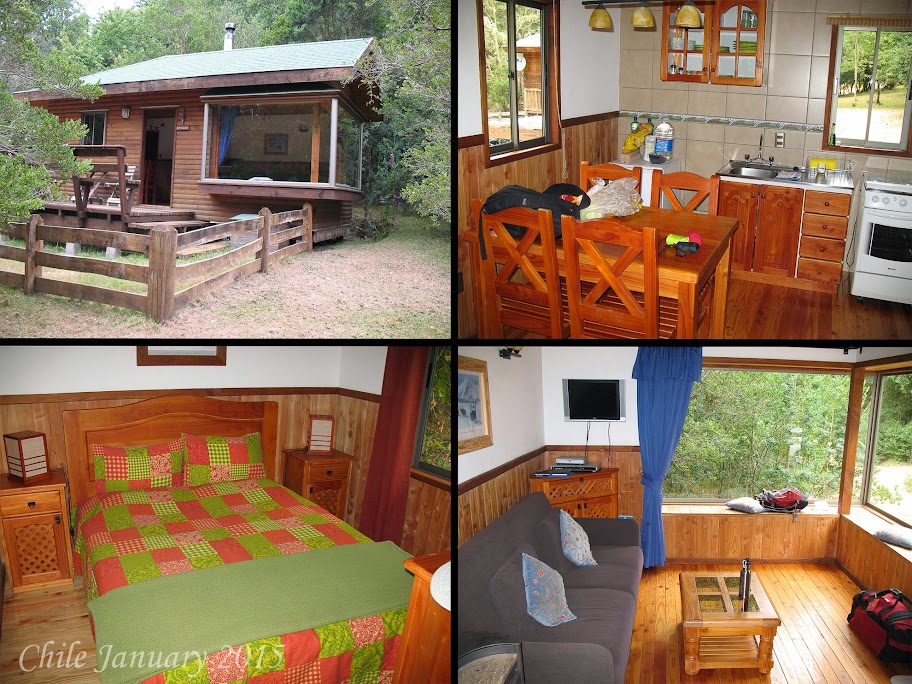
The husky farm has four houses / cabins on the property. The main house is where Inga and Konrad live and the dogs reside. Then there are three cabins that they rent out to guest. The first is more like a house with multiple bedrooms. The other two or more what you might call one bedroom cabins. All are furnished with traditional furniture and very comfortable. The land is laid out so that the main house is in one area and the cabins in another. All walking distance but separated enough for privacy.
 After we got situated, Inga invited us over for sausage they were grilling as well as beer and wine. Another couple that had come specifically to see and train with the huskies, joined us for sausages and drinks. When we had booked our cabin at the husky farm Inga had offered to help us book our activities. The two things we wanted to do while at the Lake District was climb Vallarrica Volcano and white water raft. This area reminded us a lot like Colorado and had many of the same activities most geared around the outdoors. Konrad contacted the guide service they like to work with. They suggested rafting our first day and climbing the second. We needed to be at Aguaventura Expeditions at 8:30 AM the next morning.
Day 13
We had a great nights sleep. On the husky farm there are more than just Huskies, they have 5 sheep, several chickens, 3 or 4 ducks, 2 fox, and 3 or 4 cats. During the night you can hear the different animals frolicking around, in a very pleasant way. The sheep are kept in the grounds surrounding the cabins to help keep the grass at the proper length.
We headed to Puncon for the rafting trip. The Lake District has three main villages. Pucon the largest and most touristy, Vallarrica is slightly smaller, and Lican Ray which seemed the smallest, more where the locals hang out. All three villages reside on rather large lakes.
We had our choice of rafting trips both were 3-4 hours. One covered the top of the river and the other the bottom. It was explained that on the top we would hit class 5 rapids and on the lower the Rapids were more like class 2 and 3. We opted for the upper.

Our guides were great very focused on safety and fun. I have now rafted in West Virginia on the New River, Uganda on the Blue Nile, Idaho on the Snake River, Colorado on the Taylor River, and Zimbabwe on the Great Zambezi River. Many of these trips were over several days. My point is I am very comfortable rafting on fairly technical large rapids. With that said, I am use to the guides commands being yelled out in English. At this point in the trip my Spanish is fairly strong, but when you have to translate commands such as "paddle left", "full back paddle", "get down" from Spanish to English as you are approaching a waterfall your Spanish skills go out the window and you do two things. Look at what the Spanish speaking folks are doing, make your best guess as to what you should do.
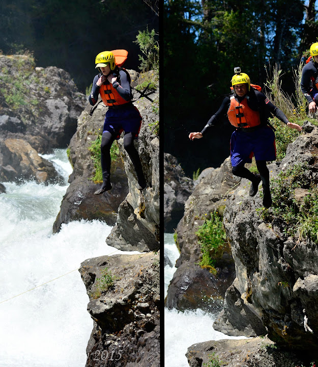 Our guide was great, I was not, since I was in the front of the boat, if I got the command wrong most of the other paddlers followed my lead and we all got it wrong. The trip was a lot tamer than advertised more of a class 3-4 trip than class 5. One rapid we walked around may have been a class 5. Once we walked around we had to jump from a cliff to get back to the river about a 50 foot fall. This jump was a blast. The whole trip was great, but the jump was special.
We return to Puncon in the late afternoon, we decided to have lunch at a restaurant Konrad had recommended, la Maga. We must have been starved as we ordered enough for a family of 6, the waiter just looked at us as we kept ordering. Margarite and I had both ordered the grilled salmon. Not only did we order a lot, the portions were huge. We could of split one order and still had left over's.
At 4:00 PM we returned to the guide shop to get fitted for our equipment for the next days climb. The sky was clear and from most places in town you could see the volcano. This is an active volcano so depending on the wind you might see smoke rising from the top. While we had much of the necessary equipment with us, for safety reason they wanted us using their equipment. Here is he list of equipment needed: Boots, Gaiters, Ice axe, Protection layer, Pants, Jacket, Gloves, Mid section cover (for sledding), Gas mask (to protect us from fumes from the volcano), Crampons, Pack. We needed to provide: Wool socks, Under layers for warmth, Eye protection, Hat/cap, 2 litters of water, Snacks.
Once we were all set we headed back to the husky farm, to visit with the dogs before calling it a day.
Day 14
We needed to meet at the guide shop at 6:30 AM, we decided we would leave the farm at 5:00 to play it safe, wake call at 4:00 AM
We arrived at the shop early as planned. We were able to get our things arranged and relax a little. It
 was a 40 minute drive to the volcano. The guide cautioned us about the weather conditions not being optimal. We were given the option to not go, we all voted to continue on. There were two vans, ours waited as the other one left. Finally Ben showed up, Ben apologized for holding us up. He explained that his girl friend did not wake him until 10 minutes before we needed to meet. He went on to explain that he had arranged all the food and water for him and his girlfriend but his girlfriend had left his water back at their apartment. He had to run three blocks to buy some water. His girl friend sounded like a real bitch. As the ride went on we found out there was more to the story. At about 11:00 PM the night before Ben went out for a cigarette not to return until about 4:00 AM. Apparently he ended up in a bar, so when he did return at 4:00 AM he was drunk. In fact we were pretty sure he was still drunk while he was telling us this story.
 As we left Puncon the sky was covered with dense clouds, as the van started climbing in elevation we saw we were really in a fog and were quickly climbed above the fog. Looking back it was like a cotton blanket covering Puncon. When we arrived at the volcano, except a small cloud at the top of the volcano resembling and umbrella swirling in circles, the sky was as clear as could be. Based on the speed of the swirling cloud, there were high winds at the top of the volcano. The guides again gave us the option to cancel, again we all agreed to go on. We had a choice we could ride the ski lift about 25% of the way up or we could hike that 25%. The lift cost 9,000 pesos and would save us an hour of hiking, it was unanimous take the lift! The sky and scenery were beautiful. Looking back at Punco you could see the fog receding but still covering most of the town. Looking up at the summit the cloud was growing and spinning even faster meaning
 the winds were picking up.
We got a quick lesson on how to use an ice axe for hiking while hiking the glacier. We also learned how to use the ice axe if we fell and needed to stop our free fall down the volcano.
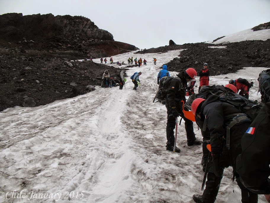
We were the first group on the volcano. A few of the guides and one guest were carrying skis, they planned to ski down the glacier. I assumed we were hiking back down. Never assume!
We continued our accent kicking our toes into the snow as we went to make sure we had good footing on the ice. One of our guides went ahead and reported the winds were really picking up. Our team leader decided we would take a break and put on our crampons. Crampons are metal spikes that attach to your boots to make sure you do not slip on the ice and snow. As we put our crampons on other groups passed us by. Once we started up the
 volcano again we quickly passed the other groups as they were slipping and sliding without crampons. The wind was blowing between 40 and 50 miles per hour. We continued up the volcano. Our guides kept us close together, visibility was down to a few feet. Again one of the guides went ahead to scout things out.
The guide returned with bad news, in his words, "No visibility, high winds, and crevasses, do not make for safe climbing." We all agreed we would head back down. We removed our crampons, then pulled out an item they called a diaper. Think of a cafeteria lunch tray shaped like your butt, with a handle that strapped to your protective clothing.
We sat on this diaper and slide down the glacier. What I would call a semi controlled fall. We came down fast, slowing ourselves when needed with the ice axe. Once we hit the area where the ski lift dropped us off we hiked the rest of the way down. All told about 4 hours, 3 and a half hours up about 30 minutes down. Once we were back in Puncon we checked all our equipment in. We hung out with the group at the guide shop for a while. There is a roof top bar to have a few drinks and reminisced about the days climb. We had not been to Lican Ray Mi Mesa Restaurant. There was not much to the town, a few restaurants and shops, the lake front and that was it.
 and still had a few hours of daylight left, we thought let's check it out. We had a late lunch at
It was time to head back to the husky farm and pack up for our next part of the trip, Patagonia!
Day 15
It is with a sad heart we depart the husky farm, while we are on to our next adventure we feel we truly did not experience all that the husky farm, Inga, and Konrad had to offer.
Tonight we will be in Punta Arenus, there is no easy way to get there from here. We flew back to Santiago (yes we flew north to go south), changed planes for a flight that stopped a few times and finally arrived in Punta Arenas.
Punta Arenas, Chile - Chilean Patagonia's most important city, Punta Arenas was an important supply station for ships prior to the completion of the Panama Canal and the home to mansions of the wool
 barons who transformed the economy of southernmost Chile and Argentina. The main sights are the Plaza Munoz Gamero, with its monument to Hernando de Magallanes (Magellan), the regional museum (formerly the Braun-Menendez mansion), and the cemetery—graves and monuments to the first settlers and pioneer families from throughout Europe, including Yugoslavs, Britons, Italians and Spaniards. With the region's only commercial airport, Punta Arenas, 1,915 miles south of Santiago, is the gateway to Tierra del Fuego, large offshore penguin colonies, Torres del Paine National Park and other more remote destinations. Fort Bulnes, 35 miles south along the Strait of Magellan, is a reconstruction of Chile's initial 19th-century settlement; nearby is the site of Puerto de Hambre, whose 16th-century Spanish settlers starved to death during a bad winter.
We arrived in Punta Arenas at 6:30 PM we have booked ourselves at the Cabo De Hornos Hotel on the main plaza in Punta Arenas the hotel is historic and rather elegant. We decided to venture out to find a meal. The town was like a ghost town, frozen in time. There were very few restaurants and not one was open. We returned to the hotel for an excellent dinner.
Day 16
Today we have a 5 hour drive to Torres del Paine National Park, which is where we will be staying for the next 4 nights. We decided a run was in order so we did a quick 6 miles, had breakfast all before our 8:00 AM pick up time, which turned into 8:45 AM South American time. It seemed everybody was given a different pick up time, ours being the earliest at 8:00 AM and Ben and Olga being the latest at 8:45 AM. Never leave a man behind, we all waited for Ben and Olga. There were 4 couples traveling in our van.
The ride was pleasant but long. Torres del Paine National Park is located in a part of South America
 called Patagonia. The southern Chilean portion of Patagonia, South America's southernmost region (it spans both Chile and Argentina), is normally reached by air through the city of Punta Arenas or, alternatively, overland through Argentina. Patagonia's rugged and varied scenery, including fjords, vast pampas, lakes and glaciers, is filled with coastal wildlife, such as elephant seals, sea lions and penguins. The weather can be harsh—expect a lot of rain and wind—but snow is uncommon at lower elevations, at least in the summer months.
Torres Del Paine National Park, Chile - On the edge of the southern Patagonian ice field, 1,860 miles south of Santiago, the wildlife and scenery, both in and around Torres del Paine National Park (pronounced Torr-es del Pie-nay) are spectacular. The "Torres" of the park's name are three massive granite "towers" of the Cordillera del Paine range that reach 10,000 feet. Herds of sheep and guanacos (wild relatives of the domestic llama) graze the sprawling steppes; fields of wildflowers cover alpine meadows; lush, southern beech forests cover the hillsides observed by soaring condors; and icy rivers round out the scene.
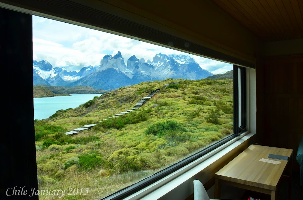
 We will be staying at Explora Patagonia for the next 4 days. We arrived at 1:00 PM met with our guides and picked what they termed a demanding hike that would start at 3:00 PM. The hike was called, Cornisas this is a half day hike under the heading of advanced, 6 kilometers in distance and one thousand feet of elevation gain, things to see, cliffs, Lake Pehoe, as well as many panoramic views. We were instructed to get settled in our room, lunch would be at 2:00 PM with the hike at 3:00 PM. The hotel is simply magnificent, built into the hill side on the lake with unbelievable views. We had lunch at 2:00 PM joined by Nick and Linda a couple originally from the UK, that now reside in Houston, TX. At 2:55 PM we had not received our lunch yet, so I alerted the guide. The response I got was unexpected, "I guess you need to decided, do you want to have lunch or go on a hike, you can not do both!" All of sudden I realized at Explora Patagonia, the customer was never right. I simply said, we are adults have our own brains, a map, so we can do both.
I returned to our table and finished a rather enjoyable lunch. Typically for the Cornisas hike the van
 drives you about 6 kilometers from the hotel, you then hike to the top of the ridge line, and followed it back to the hotel. For Margarite and I, we would hike the 6 kilometers to the trail head as the van was long gone.
Once we found what we thought was the trial head we started our hike. A good hour behind the rest of the group. The trail was overgrown and poorly marked. We navigated our way through the overgrown brush until we found what seemed like a hiking trail, going in the right direction. We continued to gain altitude and we're heading in the right direction, we assumed we were on the right trail. The views were stupendous, breathtaking, unbelievable. We had now hiked for two and a half hours. The hike was scheduled 3.5 hours. Knowing we walked the first 6 kilometers rather than
 been driven in the van, I thought by now we would have caught the rest of the group. I calculated we hike more than twice as fast as the average hiker and should be able to see them soon, no sign of them. This did not give me great confidence that we were on the correct path. We continued hiking rising and falling with the ridge line. We could now see the hotel and were sure we were going in the right direction. We had been on the trail for about 5 kilometer when it descended quickly. From our vantage point we could see the remainder of the trail, a few hundred meters in front of us we could see our group. We picked up our speed and caught the group within a few hundred meters of the hotel.
Our guide was shocked we caught them.
At 7:30 PM we HAD to attend an orientation to the hotel. This was required, like I said, at Explora
 Patagonia the customer is never right, it is their way or the highway. When we checked in to our room I noticed the room safe was locked and thus unusable. I reported this to the front desk. I was told it would be unlocked shortly. When we returned from the hike it was still locked. I again asked for it to be unlocked and again was told it would be done shortly. After dinner I again requested to have the safe unlocked, I was told they came to our room, but since I did not answer they could not unlock my safe. Like I said their way or the highway. They knew I was at dinner, they scheduled it, so why knock at my door. Just unlock the safe.
Finally they walked with me to our room and unlocked the safe.
Day 17
Today we are doing two hikes, the morning hike is Lago Grey an easy hike of 5 kilometers, the highlights are the grey glacier, beech, forest, and icebergs. Our guide Pueblo we were told is one of the best. He gave us a lot of detail about the rock formations, plants, birds, and wildlife we saw. He
 explained why the water in each lake was a different color. (It has to do with the sediment).
It was a very relaxing and enjoyable hike.
We returned for a fantastic lunch. Mushroom risotto for me and grilled salmon for Margarite.
The afternoon hike is called Luguna Largo our guide was Christina the hike was 2.5 hours covering 5 kilometers. We hiked to Laguna Larga which gives you great views of the peaks and ice caps. We also saw a family of guanacos, but no Pumas. From Laguna Larga we hiked to a very spectacular water fall.
After two easy hikes, Christina recommended we do the British Camp hike for our next days hike.
Dinner was awesome.
Day 18
Today it is the British Camp hike. Pablo is our guide again, he is as excited as Margarite and I. The British Camp hike is an extension to the French Valley Hike. There are six guest doing the French
 Vally Hike Hike. We all took a boat across the lake to start the hike. Pablo explained we would be going 10 kilometers further than the other group so we may have to wait for the boat to pick us up if they have already departed for their return boat ride back to the hotel. He made this statement, as a challenge, that we needed to complete our hike by the time they completed their shorter hike. The name of our hike is Valle Frances Britancio. It is listed as 26 kilometers and 10 hours in duration. Pablo said we would cover 28 kilometers as we would hike a little further to a look out point.
The hike started out fast, about 5 kilometers an hour. At this rate we would cover the hike in just over 5 hours. Once we hit Italiano Camp about 8 kilometers in, the paced slowed as we started to climb and the terrain became more rocky. The hike was beautiful passing through forest and rock fields
 much of the hike was along a rapid filled river. All around us were peaks covered in ice, avalanches happening ever few minutes, it sounded like thunder storms all around us. We reached British Camp about 3 hours into the hike. We had a nice lunch, relaxed and enjoyed the views. Now it was time to head back. Though we hiked back exactly the way we came the views were drastically different, but just as spectacular.
With 8 kilometers to go we caught the other group and pass them, much of the return hike Pablo and Margarite were running and I was trying to stay with them. From start to finish it was 7 hours and 20 minutes. We waited about 45 minutes for the other group to meet up with us at the boat. What a great day, but I am beat!
We later found out Pablo is a past world trail running champion. We never had a chance of keeping
 up with him.
Time for a nap and then dinner.
Day 19
Today is our last full day in Patagonia. We will sure miss the beauty of Patagonia. We decided to save the best hike for last, the Base of the Towers. This is a 8 kilometer hike one way, 16 kilometers round trip, with a great deal of elevation change.
We have two guides for today's hike, Manfred or Manny and Thomas, there are six hikers joining us, Becky and Eric from Philadelphia, Will and Grace from Seattle, and two frat boys from Ohio. We quickly broke into two groups, Manny with the majority of the hikers, and Thomas with the frat boys.
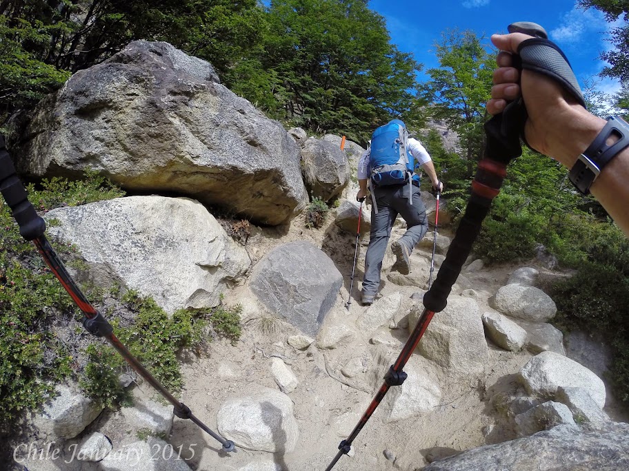 The trail started out flat, but changed quickly, and grew steep and gravely. We climbed about 300 meters in a kilometer and a half, reaching what they call the wind tunnel, a steep valley that normally has powerful winds. Today no winds! As we continued along the ridge of the valley the views were breath taking, looking down on the narrow river created from the melting glacier. As steep as the trail up was, it was just as steep down as we reached the Chilean Camp. We were about 4.5 kilometers into the hike. We took a short break allowing Thomas and the frat boys to catch up. Twenty five minutes later they joined us, immediately telling us they will be renting horses for the hike back.
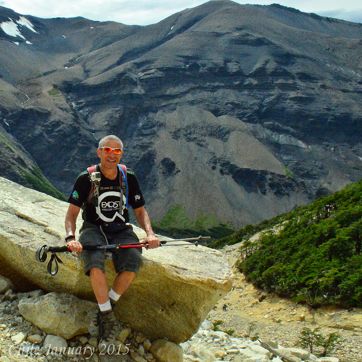 We still had 3.5 kilometers until the base of the towers, horses were not permitted on this section of moraine. This type of area is created by the glacier pushing the rock to the side as it makes it way down the mountain. This creates tough hiking conditions, especially if you have weak ankles like me. As we approached the base of the towers Manny told us to keep our eyes down and focused on the trail. Finally all at once he had us look up, what a sight. The three towers seemed to grow right out of the glacier lagoon.
the trail. The frat boys told us to go ahead they would catch up, we were not sure they would. The trail was what you might call steep rolling hills, it seems you would go up for a few hundred meters, and then down and equal amount for a few hundred meters, never really gaining any elevation. With 1.5 kilometers to go, the trail got very steep and very rocky, this is called
We enjoyed lunch at this picturesque setting, the weather was perfect, warm and sunny, very unusual
 for this area. About 40 minutes later the frat boys showed up, we got a group picture and then started our trek down. The trek back was slightly faster than the trek out, but just as hard, going down steep rocky trials can be very stressful, a little mistake can create a big problem.
We beat the frat boys back by about 30 minutes, even though they rode horses, the second half of the return hike. The benefit for us, we drank their beer.
for this area. About 40 minutes later the frat boys showed up, we got a group picture and then started our trek down. The trek back was slightly faster than the trek out, but just as hard, going down steep rocky trials can be very stressful, a little mistake can create a big problem.
We beat the frat boys back by about 30 minutes, even though they rode horses, the second half of the return hike. The benefit for us, we drank their beer.
We got back to the hotel, had a quick dip in the freezing lake to relax our sore muscles, and then off to dinner.
Day 20
Today we are packing, as we have a 5 hour drive back to Punta Arenas where we will be catching the Cruceros Australis - for a 3 night cruise through the fjords and glaciers of the far southern reaches of the continent, This trip offers excursions from the ship daily by zodiac, and the opportunity to visit
 areas otherwise inaccessible.
We arrived at Punta Arenas at 2:00 PM and much to our surprised we were dropped of at the center of town, not only far from any boat, but the water was several blocks away. We learned check in for our cruise was at the office where we were dropped off.
We checked in and got some disappointing news, yes we were checked in, but we could not board until 6:00 PM. We had planned to board, change our clothes, and go for a run, before departing. We now had 4 hours to kill, we stopped for lunch and then walked down to the dock. We noticed security was limited so we went and boarded the boat. The crew was confused, how did we get to the boat. They all spoke Spanish it was clear to us they wanted us to disembark, we just played dumb acting like we did not understand them. We were hoping to find our cabin and change our clothes.
 They finally found an English speaking crew person that explained to us what we already knew, we had to leave as boarding would start at 6:00 PM. We returned promptly at six and were the first to board. Our cabin was on the fourth floor, with a great view. While I had to pay for this cruise, the cruise line is a small boutique line owned by a Turkish shipping tycoon. This line is like a hobby to him. Another hobby he has is poker, and that is how we had met. A few years back I was playing poker in Prague, Czech Republic we met and became close friends. While he would not comp me the passage, (I guess we are not that close of friends) he did get me a great cabin at the economy price.
The boat, Via Australis, is an expedition cruise ship, a small cruise ship, with a shallow keel, 40 cabins maybe 80 passengers when fully booked. The concept is to go places where only this type of boat can go, a type of Eco-Tourism. Once unpacked we took a tour of the boat, 5 levels with the 5th being an outside observation deck. Each level has a common area. At 7:00 PM we got a detailed orientation of what would be happening over the next few days. Each evening we would sail to another location and each day we would have two excursions taking us to see parts of the world very few people ever see.
 Dinner was at 8:00 PM, which was quickly approaching, the dinning room was on the first deck. We were assigned to table 11, we are not sure how the tables were assigned. Joining us at our table were George who is a wood specialist, he actually has a PhDs in Wood, (I can not make this stuff up), George is also a world class oarsmen, ironman tri-athlete, and just recently tried a stint as an actor.
Joining George is his mistress, a distant heir to the thrown of England, Susana, both are originally from Ireland but now reside in England. A very interesting couple. To their right was Karl and Ingrid from Germany, unfortunately their English and Spanish were a little weak and my German is very rusty. With the dinning room being rather loud it was hard to communicate with them, I truly wish I got to know them better. To their right was Sandy and Markus, both currently live in Switzerland, Sandy was born in Hollywood, California she is the illegitimate daughter of Woody Allen, she is not sure who her mother is, but based on her age, hair color, and sense of humor, I am fairly confident her mother is Carol Burnett. Mix the sense of humor of Woody Allen and Carol Burnett and you get Sandy. Markus also known as Christophe (at least in North Korea) is Sandy's husband. He works for a Swiss manufacture, importing and exporting to North Korea and China. At least that is his cover story. Christophe actually works for a Swiss bank and helps the politicians of both North Korea and China launder their money out of the country. Dinner ended at 10:00 PM there was a party after, we had had a long day and decided to turn in for the night.
Day 21
 Today we woke as the boat was completing our overnight voyage to Brookes Fjord. This area is a natural amphitheater shaped by glaciers that are in constant movement. Once we anchored we boarded the zodiacs for our first excursion. There were to options a short walk or longer hike. We opted for the longer hike, everybody from our table joined us except Sandy. Sandy had recently fractured her right foot and was still recuperating. The hike started out flat and quickly turned steep,
as we gained height the views became more amazing, allowing us to see the complete glaciers. The hike was only 1.75 kilometers, but took over 2 hours because of all the picture taking.
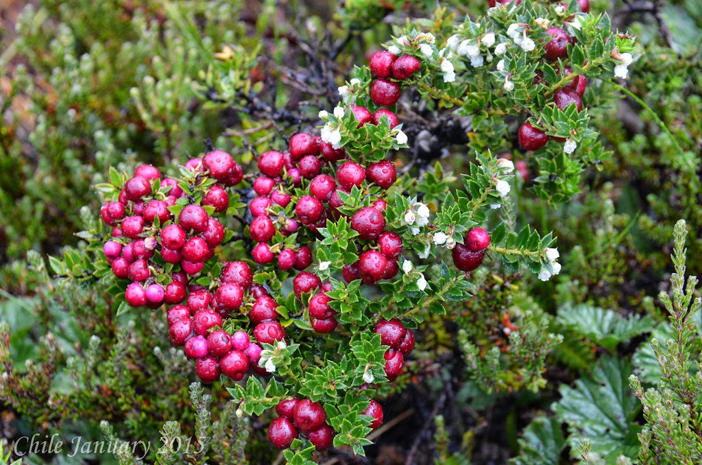 We returned to the boat and navigated the Almirantazgo Sound to our next adventure. At 3:30 PM we
anchored this time at Ainsworth Bay which is a site within Aberto De Agostini National Park. We observed the Marinelli Glacier descending from the Darwin Mountain Range. Here we took a walk through the woods, we learned about how the beavers which were introduced to the areas for the fur trade have taken over, there are now over 100,000 beavers which are causing a lot of destruction to the trees. They are working on a environmentally friendly way to eradicate the beavers from this area.
Dinner was served at 8:00 PM, this is late for us, our table was a very fun group and help us get a second wind. After dinner was karaoke while Margarite and I passed, the rest of the table took the opportunity to sing. Apparently George and Sandy did a duet that was to die for. I will pay a dollar to anybody that has that video.
Day 22
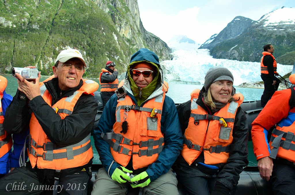 This mornings excursion is a zodiac ride, we will not step on the land but we will go through the ice
fields and hopefully see some wildlife. The area is know as Parry Fjord we motored to the far end of the Fjord seeing the glaciers up close as well as a few leopard seals. One of the seals was molting it's skin, it was important that we did not disturbed the seal, it is not healthy for them to enter the water when they are molting.
In the afternoon we were hoping to visit an area where a colony of elephant seals live, unfortunately the winds were to high for the zodiacs to land so we went to plan B which was a beautiful hike. We started in Almirantazgo Bay and followed the glacial river toward the glacier. Some refer to a glacial river as a milky river as the river has a grey milky color from the sediment the glacier has brought with it. We hiked up a steep moraine which is a
 rocky hill side produced by the glaciers movement. From the hill side we got a full view of the glacier, river, as well as our boat. There was a condor flying above. It is very hard to get a perceptive of how large these items are. The condor has a wing span of 3 to 4 meters 9 -12 feet. The glacier is hundreds if not thousands of meters high and goes on for many kilometers. Looking at these sites none looked as large as they truly are. Sandy tried to join us on this hike but her foot started to throb and she had to head back.
 Tonight is our last night and after we had a short picture show and video presentation of the trip which George stared. George autographed a personal copy of the video for each of us.
Day 23
Today we will disembark for the last time. Before that we had planned to visit Magdalena Island
located in the middle of the straight of Magellan. This is were a colony of over 100,000 South American penguins live, with the winds still high we were unable to use the zodiacs, and this excursion had to be canceled.
Not sure where I will head from here.
Cheers,
Doug
PICTURES
Here I am on a plane heading to Santiago, Chile, and then onto San Pedro. Why Chile, you ask? Since I left Botswana, Africa (3 years ago) in search of a new home. I have been asking visitors to my website www.LifeOfDug.com to decided where I should go in search of the perfect place to called home.
To my surprise (not so much) Margarite decided to join me in this adventure. Luckily my free business class strategy worked. Not only business class, but lie flat beds. Our flight departs at 9:00 PM and lands at 7:00 AM a good night sleep should be invaluable.
This is not my first time to South America, back in 2005 I spent some time in Peru just north of Chile. Chile is sandwiched, between the Pacific Ocean and the base of the Andes. The Andes are one of world's great mountain ranges, Chile boasts some of the world's most varied and dramatic landscapes. To comprehend its diverse geography, imagine a single country stretching from Baja California through California, the Pacific north-west, and up to the Alaska Panhandle. Chile's length—including the entire length of its jagged coast and islands—is an amazing 7,633 miles in all, making it the 19th-longest country in the world when measured by coastline, and the second-longest in South America.
If you are already bored you can watch the video instead I like to call it 30 days in Chile in under 15 minutes.
Modern Chile reflects Spanish, Basque, British, German and Croatian ancestry, but the bulk of the population is Mestizo. Even so, there are still a million indigenous Mapuche in the south, a nation that remained autonomous until the late 19th century.
With Chile being so long I had no idea where to go first? I decided I would travel from north to south.
I need to give a shout out to Jennifer Gillmore of Travel Beyond her insight in helping me plan this trip was fantastic, I could not have done it without her.
First stop San Pedro. San Pedro, Chile, is a charming colonial village, with a large central square, the 18th-century adobe San Pedro Church, and streets lined with low-rise shops, restaurants and small hotels and hostels. Barely an hour southeast of Calama and 1,040 miles north of Santiago, San Pedro is at an elevation of 8,100 feet. The main attraction here is R.P. Gustavo Le Paige Museum, which exhibits pre-Columbian mummies and other artifacts unearthed by a Jesuit priest who was also a noteworthy archaeologist.
We arrived in Santiago to a bit of a problem. I had a great night sleep but when the flight attendant
You will never believe this! (See picture) Yep, the gate agent let me work off the business class fare. I managed the queue for domestic check in. Four hours of work and they called it even.
While I was working Margarite decided to check our bags to Calama. We NEVER check bags because of the hassle if our luggage gets lost. Margarite thought, it is a short flight with no connections, what could happen.
As we approach security, Margarite turn white as a ghost, I thought she was going to faint. Maragrite had left all her papers and money in the luggage she had checked. How do we get past security, with no identification? I gave Margarite my LAN airlines flight credentials. The ones I got for the four ours of work I had done. I said, walk through the airport security section for employees. Hold up my credentials but put your fingers over my picture and name. Walk quickly in a crowd and act like you own the place. It worked like a charm!
I arranged to stay at a resort called Tierra Atacama, a few years back a fairly good poker player had lost some money to me that he could not repay (or did not want to). He told me he owned a resort in San Pedro, Chile, and if I was ever there, he would take care of the bill. Payback time!
Here is what we decided to do:
Afternoon of our arrival - Atacama Salt Flat (Chaxa Lagoon & Flamingo Reserve)
Day 1
Morning - Guatin / Puritama (hike)
Afternoon - Quebrada Del Diablo (mountain bike)
Day 2
Morning - Mirador del Viento (mountain bike)
Afternoon - Guatin - Gatchi (hike)
Evening - Star Gazing
Day 3
Full Day - Tataio Geysers (4 wheel drive)
We also fit is a self guided walking tour of San Pedro. The museum's mummies are quite a sight—some are displayed in glass cases, others in earthen jars, and most still have their skin, eyelashes and thick brown hair. San Pedro also has one of Chile's landmark colonial churches and several nearby archaeological sites, including the restored fortress of Pukara Quitor.
Reserve) The journey starts with a brief visit to Toconao village where the square and the historic church are the main attractions. We also visited a local family who lives off the sales of their handcrafts. After Toconao we continue to the National Flamingo Reserve in the Atacama Salt Flat. There are three types of flamingo to be found here, living off the microscopic lagoon life. The views of the Andes as the sun sets are truly amazing.
This excursion well worth the price, we have seen flamingos in Tanzania though once you have seen one you have NOT seen them all. The Chilean flamingos have black tipped wings that give them a unique color when they are not flying. The salt flats, are flat when you look at them from afar, but up close you see the surface is very bumpy and lumpy. The reason for this is the salt is brought up from
Our guide Leo was very informative and set up a nice snack of fruit, cheese, and crackers for us to enjoy as we watched the sun go down.
Dinner was served at 9:30 PM when we returned. The food has been excellent.
Off to bed as this will be our first sleep in 35 hours.
Day 1 (full day)
After breakfast we met our guide her name is Karenze our hike is titled - Guatin / Puritama it is scheduled for 2.5 to 3.5 hours, this includes a one hour drive to the start of the hike, we thought we would start out with a medium hike as we are at 8,000 feet and will be hiking to a little over 13,000 feet.
The valley we are exploring is one of the driest places on earth, so it was very interesting to see this stream / river flowing through the canyon. We followed the paths carved in the canyon by the goats and sheep.
After about a hours hike we reached the source of the river which was a natural hot spring. What a great reward after a hot hike. Again we were served a nice snake where I indulged myself with a beer.
This afternoon, will be an easy mountain bike ride.
Devils Canyon / Catarpe - This is billed as a medium ride. Joining us is a couple from Brazil, Pedro and Medellin. We departed the hotel on bikes heading north towards the Salt Mountain Range, and beautiful Devil's Canyon. The ride takes place at an average elevation of 2,400m/8,000ft. After crossing the San Pedro River we arrive at the Canyon, which is flanked by clay cliffs and has a sandy bottom in places. The ride is a constant gentle climb until we come out of the labyrinth on to the Catarpe plateau. The return journey follows the natural course of the San Pedro River until we reached the village and hotel.
Here is a quick overview of the meals we are and will be enjoying. - Traditional Chilean food tends to be simple and hearty peasant fare, such as cazuela (a thin stew with potatoes, corn on the cob and either chicken or beef), empanadas de horno (baked meat pies, usually with ground beef), locro (a meat dish with potatoes and vegetables), charquican (a dish with vegetables and dried beef), humitas (similar to Mexican tamales) and pastel de choclo (a corn-based casserole with onions, hard-boiled eggs and beef or chicken, easily the best traditional meal).
Fish and seafood, though, are the highlights of Chilean cuisine. Try parrillada de mariscos, a mixed grill of seafood, but don't miss corvina (sea bass as its more commonly known trade name), congrio (conger eel), locos (abalone), centolla (king crab) and machas (razor clams). More adventurous diners can try less conventional shellfish such as the picoroco (giant barnacle) and erizo (sea urchin). On the island of Chiloe, the curanto, a massive combo of shellfish, seaweed, dumplings and meat, is legendary. In Patagonia, game dishes such as wild boar, guanaco and rhea (the latter two are now farmed in captivity) are becoming common menu items.
With vineyards ranging from Limari Valley in the north to the Maule and beyond in the south,
Chile's national cocktail is the pisco sour, which blends the local grape brandy with sugar and lemon, then tops it with bitters. Other drink specialties include borgona, a red wine punch prepared with sparkling water and fruit, and cola de mono, a Christmas drink similar to eggnog. German settlers brought with them the tradition of brewing tasty beers, and the local chopp—draft lager—is excellent. In recent years, many new artisanal brews have appeared on the market.
Predominant Religions: Christian (Roman Catholic, Protestant); though many Mapuches and Aymaras communities are nominally Catholic, they practice their own religious beliefs.
Day 2
After a great nights sleep except for the few times the local dogs decided they should bark excessively. We met up with our guide for a more extreme mountain bike ride.
Windy Lookout Point / Moon Valley, the Dune - The description says 2 - 3.5 hours, level of difficulty
The ride started out similar to the ride the prior afternoon. It was just Margarite, our guide, and I. When we entered the canyon we went left, instead of the right, we took the afternoon before, that is where the similarities ended. The trail become a
Once we reached the top of the canyon we rode the rim, very beautiful yet at the same time stressful. One wrong move and you're doing a few thousand foot jump!
At one point there was a 3 foot drop Margarite was in front and cleared no problem. I was not so fortunate, leaning to far forward my front wheel dropped and I went head over heals, my handle bars turned gouging me in the ribs, cracking a few. The good news, it only hurt when I took a breath, the bad news, I can not live without taking breaths.
I dusted myself off and we continued the ride, just fabulous.
Once back at the hotel we took a little break had lunch and then headed out on our afternoon hike.
Guatin / Gatchi - Level of Difficulty: Medium - Here is the description - depart the hotel in a vehicle towards Guatin Valley (2,800m/9,186ft). The confluence of two rivers takes place here; one coming
This hike is to the west of the hike we had done the day before. At first I was a little concerned it looked like the hike was going to be a little boring and repetitive. Then we entered the canyon and everything changed. The walls of the canyon were much steeper in this section the vegetation much different and the hiking was more a combination of hiking and rock climbing. The hike was scheduled for two hours we covered it just over an hour. It was just Margarite, our guide and me.
Time for a shower and dinner.
Day 3
The dogs were more active last night so sleep was rather difficult. Wake came at 5:00 am as we are departing for the geysers at 5:30.
Today we will depart Atacama but before we do we will get one more excursion.
The Tatio Geisers - This is an easy excursion most of it is driving, it will take about 7 hours. Here is
The geysers were great to see, but no where near the level of Iceland. We saw lots of lama and other wild life. Actually lamas are not wild life they are domestic. The reason this trip is so early in the morning is to arrive at the geysers while the temperatures are still low -5 Celsius. This allowed us to see the steam coming from the geysers, as the day heats up the steam is not visible.
After a short walk through the geysers we had a nice breakfast. On the drive back we stopped at a small village to use the rest room and visit a church. After that one more stop at a lagoon where native ducks, geese and even some flamingos were hanging out.
Once back at the resort we packed for our next adventure, Easter Island. The best part we got dropped
back off at the Calama airport by our driver and never got a bill. Boy do I like poker!
Calama to Santiago, over night in Santiago before catching a 6 hour flight to Easter Island.
Our flight from Calama to Santiago ran like clock work. When I booked the flights to Easter island I booked it as a connection. Calama to Santiago - Santiago to Easter Island. I did not realize there was a 12 hour layover in Santiago. Now what.
We thought perfect! We could sleep in the lobby they should have comfy seats. This worked for about an hour. It was now 1:00 AM we still had 8 hours until our flight. The front desk clerk said we needed to leave or get a room. We made up story that our flight was canceled and our wallets were stolen. What a nice guy he checked us in at no charge. Gave us a small, but nice room that allowed us a few hours sleep, he even gave us a free breakfast.
Day 4
Easter Island - Culturally Polynesian, politically Chilean and semitropical in climate, Easter Island has much to offer the modern-day vacationer. The first inhabitants of Easter Island called it Te Pito o Te Henua (the Navel of the World). Visitors today often call it the world's largest open-air museum. The island, which is 60 sq mi/155 sq km, has a fascinating—and tragic—history.
Our flight was just over 5 hours, the time change was just 2 hours, based on longitude the time
We were greeted at the airport by Peter Naef. Peter is from Switzerland, growing up he played soccer eventually playing in the World Cup. He played professionally throughout Europe and coached in the United States. A adamant bachelor until age 50 when he met the love of his life Tiare. They decided to settle in Easter Island Tiare's home. They have an adorable daughter Annabel. We will be staying with Peter and his family on Easter Island. Peter with the help of his father in law and brother in law built three magnificent bungalows that sit along side their primary home.
On the drive from the airport to the bungalows Peter gave us a quick overview of the island and a quick tour of town Hanga Roa, the largest and really only town on the Island. The name on the bungalows are Hareswiss meaning Swiss House. The bungalow was perfect, from the porch we got a view of the sea, inside there was a sitting area / kitchen table, a kitchen section and a king size bed along with a twin bed. The bathroom was appointed nicely with great water pressure in the shower. All the windows had screens, so we could enjoy the nice sea breezes without the worry of bugs.
Sprawling and densely wooded Hanga Roa, the island's only town, is the site of the much-improved Father Sebastian Englert's Archaeological Museum. Nearby sites such as Ahu Tahai, the spectacular Rano Kau crater and its Orongo ceremonial village—site of the "birdman" cult that superseded the moai as objects of veneration—and Ahu Vaihu are all easily accessible from town. The highlight of any visit to Easter Island is the iconic moais, or mysterious stone monoliths, that have intrigued Western visitors for centuries. If it weren't for those strangely beautiful ruins—massive carvings of abstract human figures, toppled and abandoned long ago—few would likely venture here.
Once we were settled we walked to town, about a 25 minute walk, we took our time walking along the coast visiting our first moais or figures. We stopped at the bank to get some pesos. Most establishments took credit cards, but we wanted some cash just in case. We were both getting hungry so we picked a restaurant Te Moana along the water known for it's Ceviche, raw fish prepared in lime and or lemon juice.
After a great meal we walked through town, picked up a few snacks and headed back to the bungalow. With the adjusted time zone sunrise was at 7:30 AM, but sunset would not be until close to 10:00 PM. We hit the sack early, we had, had two long days of touring and travel and wanted to be well rested for tomorrow.
Day 5
Today Peter will be giving us a private tour of the island. If you ever choose to visit Easter Island I highly recommend Peter as a guide. Two big reasons, his tours are private in our case just the two of us, at most 4 people, though Peter is Swiss he has been visiting or living on the island for
We went for a short run along the coast to stretch our legs and then met up with Peter at 9:45 AM.
The main attraction or Easter Islands are the Moais. No one knows exactly the meaning of the Moais, and exactly how they moved the Moais from the quarries where they were carved to the coast where they were displayed, many time over 5 kilometers away, some weighing 5 tons or more. As we toured, we saw Moais in all different stages of life, from partially carved to fully restored.
Rano Raraku quarry alone has nearly 400 moais. At the quarry, you can see moai in various stages of completion, from a rough outline in the ground to the nearly finished product (apparently the carvers simply laid down their tools one day, never to take them up again). We stopped at Anakena for a late lunch, Anakena is another site of moais and also a beautiful beach. It is all part of the national park system here on the island. We had some Ceviche at a little snack bar that was as good as any Ceviche we have had at fine restaurants.
Peter filled us full of interesting facts and legions about the island. After the tour I decided I had my own legion. Just like Machu Picchu, the Pyramids, Petra, the Moais were built by aliens.
Peter dropped us off in town so we could grab some dinner, another great restaurant at the end of the city dock, La Kaleta I had the short ribs, very good, and Margarite had grilled tuna. Also on the city dock is a Gelato shop, with Gelato as good as you get in Italy. We took a causal walk back to the bungalow for a quiet evening of sitting on the porch and reading.
Day 6
Peter gave us a ride into town where we rented two mountain bikes. Peter had given us a route that would cover the section of the island we had not covered the day before. First we biked from town to Orango which is a stone village and ceremonial centre. It is located on the southwestern tip of Easter Island. Built on the craters edge of Rano Kau Volcano, which is the tallest volcano on the island. The island is shaped like a triangle with three volcanoes at each point. Rano Kau which is the South East point Terevaka which is the Northern point and Poike which is the Western point. From the village Orango you could get a nice view of the island. You also got an understanding of the size of the volcanoes by seeing the size of the crater. There is a lot of history around Orango. This area at one time, worshipped the birdman.
From Orango we biked north seeing more moais. As we approached the north east coast we came across some of the volcanic tubes, often incorrectly called caves, where some hid during tribal wars; other tubes served as garden and orchard sites.
At this point the road was only passable via mountain bike or hiking. We continued along the coast returning to Hanga Roa. Peter had recommended a local fish restaurant for dinner and that is where we went. Another great meal at Tataku Vave. A true local place we did not see one tourist there. We returned the bikes, stopped for gelato and walked back to the bungalow for a relaxing evening sitting on the porch.
Day 7
Today we head to Santiago this will be our third time at the Santiago airport, but our first time staying
Santiago, like Chile in general, has enjoyed a renaissance of cultural, intellectual and especially commercial activity for more than two consecutive decades. The Andes Mountains overlook Santiago's eastern edge, and their snowy peaks provide good hiking, skiing, rafting and kayaking—and the beach is only a short drive away. Small wonder it is the country's capital and largest city, and one of the continent's largest metropolises.
Our apartment is located in the Bellas Artes district of Santiago about a 30 minute taxi from the airport.
Day 8
Our first full day in Santiago. We went for a short run along the river about 3 blocks from the hop on hop off bus to give us a quick overview and some history of the city.
Centro (downtown Santiago) is still dotted with Spanish colonial buildings and old churches, as well as many sparkling new modern buildings. Other neighborhoods house international restaurants, upscale boutiques and lively nightlife. Tourist areas are compact, and the resident Santiaguinos are pleasantly helpful. The city has a certain efficiency not found elsewhere in Latin America, and an obvious prosperous feel to it. The major drawback is that ongoing development and traffic congestion have created air pollution and smog, at first we thought it was overcast, but no it is smog.
After the bus tour we opted for lunch and then off to the market, not the grocery, but the La Vega market, we picked up some fresh fruit.
Day 9
Today we will be taking a bike tour that will focus mainly on the street art and markets of Santiago. The company La Bicicleta Verde "The green bicycle" offers several bike tours, we opted for "local life and markets morning" it was a fantastic tour. What a great way to hear about the history and changes that have occurred in Santiago. Much of Santiago is covered with street art. Some might call this street art graffiti, but it is clearly art. We spent some time on the south side of Santiago which has become the trendy side. This is where most of the street art is. We visited a poets house by the name of Pablo Neruda who was also involved in politics. From there we visited La Vega which is one of the largest fruit and vegetable markets in the world. From La Vega we toured the downtown or northern side of the city. After the tour we returned to La Vega and had lunch with the locals, then walked the streets taking in all the street art, working hard to understand the meaning
Before returning back to our apartment we decided to walk the hill of St Lucia just one block from our apartment, it was a magnificent hill, with a castle like structure and chapel at the top. This vantage point gave us unobstructed views of the city. It would soon be time to pick up our laundry so we headed back to the apartment, plus, tomorrow will be a long day.
Day 10
Today we will take a day trip to Valparaiso. Founded in 1536, the picturesque port city of Valparaiso, Chile, was named a UNESCO World Heritage site for its distinctively spontaneous hill neighborhoods and their vernacular architecture, including more than a dozen funicular cable cars that connect the port with its surrounding heights.
After about a 15 minute drive we pulled into another bus terminal, it looked identical to the first terminal, was it possible they knew we had no tickets and they were kicking us off the bus. Actually this was the terminal that you buy the tickets, about half the riders got off purchased tickets and got Pullman. We had heard good things about them. Our experience was great, clean, comfortable, and ran on time.
We arrived at the Valparaiso at 9:00 AM just two and a half hours after departing our apartment and about $7.00 US dollars lighter. Not a bad way to travel.
To get to the historical section of Valparaiso it is a twenty minute walk through a section of town that many had advised us against walking through. It was 9:00 AM on a Tuesday morning what could happen. What a great walk through an industrial and distribution section of the city. We were glad we took the walk.
Valparaiso is built into the hills that rise out of the Pacific Ocean, in some respects it resembles San
Once we reach the historic district we stopped at a lovely cafe La Panera the owner a young lady from Santiago who had recently spent time in the United State, Australia, and New Zealand spoke perfect English. We enjoyed some breakfast as well as pastries while she gave us a map and great suggestions on what to see during our visit to Valparaiso. If you are in Valparaiso please visit La Panera. We walked the streets taking in the city, hitting most of the terraced view points. Like the South Side of Santiago, Valparaiso had much street art. We visited the art museum and then took the long walk along the ridge to La Sebastiana, one of Pablo Neruda's many eclectically decorated homes, located high above the harbor. While in Santiago we were unable to go inside Pablo Neruda's home, here we could.
We learned a lot about Neruda's idiosyncrasies and obsessions. Guess this guy liked investing in real estate. Prior to the tour of the house we had lunch around the corner at Sello Verde. We had a pleasant lunch nothing special but it suited our needs. We sat on the front porch, there was also seating on an upstairs balcony with great views. Unfortunately for us, the balcony was full when we arrived.
We continued walking the streets, and taking in the sites. They have a saying in Valparaiso, "watch
It was nearing 5:00 PM and we had a few hour trip back to Santiago. We decided to walk back to the bus terminal. The city was alive the street markets, selling fruits and vegetables as well as crafts.
Our transport back to Santiago was as comfortable and uneventful as our morning ride.
Day 11
Today is our last day in Santiago we walked to the top of Funicular - Estación Pio Nono - Parque Metropolitano de Santiago, from the top we could see the entire city. We hiked up and took the funicular down.
After the walk we toured the city by foot. I like to collect bike jersey's so we walk across town to where the bike shops are. Yes a street with about a dozen bike shops.
Tomorrow morning we are off to the Lake District where we are staying on a Husky Farm.
Day 12
Early wake up call to catch a 9:30 AM flight to Temuco. We are heading to the Lake District of Chile. South East of Santiago a popular vacation spot for Chileans. The two towns we will be visiting are Villarrica and Pucon. Both towns are on Lake Vallarrica which is at the base on Villarrica Volcano.
The drive from Temuco to Vallarrica is about an hour, which is also the amount of time it took us to rent our car from Budget. Things are a little slower in South America then North America. South Americas definition of fast is much closer to Africa's definition. We arrived in Vallarrica around 1:00 PM just in time for lunch. We found a great place on the lake called Restaurant Brazas Vallarrica, I
We had arranged to stay on a Husky Farm, what is a husky farm you might ask. Just as in Alaska, Greenland, southern Chile uses huskies to pull sleighs for transportation. These huskies need to be bred and trained, thus the husky farm. The farm we are staying on currently has 49 huskies in training. The farm is owned and operated by Inga and Konrad Schaab. We arrived at 4:30 PM as the huskies were going out on a training run. What a sight.
As I write this update I am on a flight from Temuco to Santiago. I lean over to Margarite who has the
The husky farm has four houses / cabins on the property. The main house is where Inga and Konrad live and the dogs reside. Then there are three cabins that they rent out to guest. The first is more like a house with multiple bedrooms. The other two or more what you might call one bedroom cabins. All are furnished with traditional furniture and very comfortable. The land is laid out so that the main house is in one area and the cabins in another. All walking distance but separated enough for privacy.
Day 13
We had a great nights sleep. On the husky farm there are more than just Huskies, they have 5 sheep, several chickens, 3 or 4 ducks, 2 fox, and 3 or 4 cats. During the night you can hear the different animals frolicking around, in a very pleasant way. The sheep are kept in the grounds surrounding the cabins to help keep the grass at the proper length.
We headed to Puncon for the rafting trip. The Lake District has three main villages. Pucon the largest and most touristy, Vallarrica is slightly smaller, and Lican Ray which seemed the smallest, more where the locals hang out. All three villages reside on rather large lakes.
We had our choice of rafting trips both were 3-4 hours. One covered the top of the river and the other the bottom. It was explained that on the top we would hit class 5 rapids and on the lower the Rapids were more like class 2 and 3. We opted for the upper.
Our guides were great very focused on safety and fun. I have now rafted in West Virginia on the New River, Uganda on the Blue Nile, Idaho on the Snake River, Colorado on the Taylor River, and Zimbabwe on the Great Zambezi River. Many of these trips were over several days. My point is I am very comfortable rafting on fairly technical large rapids. With that said, I am use to the guides commands being yelled out in English. At this point in the trip my Spanish is fairly strong, but when you have to translate commands such as "paddle left", "full back paddle", "get down" from Spanish to English as you are approaching a waterfall your Spanish skills go out the window and you do two things. Look at what the Spanish speaking folks are doing, make your best guess as to what you should do.
We return to Puncon in the late afternoon, we decided to have lunch at a restaurant Konrad had recommended, la Maga. We must have been starved as we ordered enough for a family of 6, the waiter just looked at us as we kept ordering. Margarite and I had both ordered the grilled salmon. Not only did we order a lot, the portions were huge. We could of split one order and still had left over's.
At 4:00 PM we returned to the guide shop to get fitted for our equipment for the next days climb. The sky was clear and from most places in town you could see the volcano. This is an active volcano so depending on the wind you might see smoke rising from the top. While we had much of the necessary equipment with us, for safety reason they wanted us using their equipment. Here is he list of equipment needed: Boots, Gaiters, Ice axe, Protection layer, Pants, Jacket, Gloves, Mid section cover (for sledding), Gas mask (to protect us from fumes from the volcano), Crampons, Pack. We needed to provide: Wool socks, Under layers for warmth, Eye protection, Hat/cap, 2 litters of water, Snacks.
Once we were all set we headed back to the husky farm, to visit with the dogs before calling it a day.
Day 14
We needed to meet at the guide shop at 6:30 AM, we decided we would leave the farm at 5:00 to play it safe, wake call at 4:00 AM
We arrived at the shop early as planned. We were able to get our things arranged and relax a little. It
We got a quick lesson on how to use an ice axe for hiking while hiking the glacier. We also learned how to use the ice axe if we fell and needed to stop our free fall down the volcano.
We were the first group on the volcano. A few of the guides and one guest were carrying skis, they planned to ski down the glacier. I assumed we were hiking back down. Never assume!
We continued our accent kicking our toes into the snow as we went to make sure we had good footing on the ice. One of our guides went ahead and reported the winds were really picking up. Our team leader decided we would take a break and put on our crampons. Crampons are metal spikes that attach to your boots to make sure you do not slip on the ice and snow. As we put our crampons on other groups passed us by. Once we started up the
The guide returned with bad news, in his words, "No visibility, high winds, and crevasses, do not make for safe climbing." We all agreed we would head back down. We removed our crampons, then pulled out an item they called a diaper. Think of a cafeteria lunch tray shaped like your butt, with a handle that strapped to your protective clothing.
We sat on this diaper and slide down the glacier. What I would call a semi controlled fall. We came down fast, slowing ourselves when needed with the ice axe. Once we hit the area where the ski lift dropped us off we hiked the rest of the way down. All told about 4 hours, 3 and a half hours up about 30 minutes down. Once we were back in Puncon we checked all our equipment in. We hung out with the group at the guide shop for a while. There is a roof top bar to have a few drinks and reminisced about the days climb. We had not been to Lican Ray Mi Mesa Restaurant. There was not much to the town, a few restaurants and shops, the lake front and that was it.
It was time to head back to the husky farm and pack up for our next part of the trip, Patagonia!
Day 15
It is with a sad heart we depart the husky farm, while we are on to our next adventure we feel we truly did not experience all that the husky farm, Inga, and Konrad had to offer.
Tonight we will be in Punta Arenus, there is no easy way to get there from here. We flew back to Santiago (yes we flew north to go south), changed planes for a flight that stopped a few times and finally arrived in Punta Arenas.
Punta Arenas, Chile - Chilean Patagonia's most important city, Punta Arenas was an important supply station for ships prior to the completion of the Panama Canal and the home to mansions of the wool
We arrived in Punta Arenas at 6:30 PM we have booked ourselves at the Cabo De Hornos Hotel on the main plaza in Punta Arenas the hotel is historic and rather elegant. We decided to venture out to find a meal. The town was like a ghost town, frozen in time. There were very few restaurants and not one was open. We returned to the hotel for an excellent dinner.
Day 16
Today we have a 5 hour drive to Torres del Paine National Park, which is where we will be staying for the next 4 nights. We decided a run was in order so we did a quick 6 miles, had breakfast all before our 8:00 AM pick up time, which turned into 8:45 AM South American time. It seemed everybody was given a different pick up time, ours being the earliest at 8:00 AM and Ben and Olga being the latest at 8:45 AM. Never leave a man behind, we all waited for Ben and Olga. There were 4 couples traveling in our van.
The ride was pleasant but long. Torres del Paine National Park is located in a part of South America
Torres Del Paine National Park, Chile - On the edge of the southern Patagonian ice field, 1,860 miles south of Santiago, the wildlife and scenery, both in and around Torres del Paine National Park (pronounced Torr-es del Pie-nay) are spectacular. The "Torres" of the park's name are three massive granite "towers" of the Cordillera del Paine range that reach 10,000 feet. Herds of sheep and guanacos (wild relatives of the domestic llama) graze the sprawling steppes; fields of wildflowers cover alpine meadows; lush, southern beech forests cover the hillsides observed by soaring condors; and icy rivers round out the scene.
I returned to our table and finished a rather enjoyable lunch. Typically for the Cornisas hike the van
Once we found what we thought was the trial head we started our hike. A good hour behind the rest of the group. The trail was overgrown and poorly marked. We navigated our way through the overgrown brush until we found what seemed like a hiking trail, going in the right direction. We continued to gain altitude and we're heading in the right direction, we assumed we were on the right trail. The views were stupendous, breathtaking, unbelievable. We had now hiked for two and a half hours. The hike was scheduled 3.5 hours. Knowing we walked the first 6 kilometers rather than
Our guide was shocked we caught them.
At 7:30 PM we HAD to attend an orientation to the hotel. This was required, like I said, at Explora
Finally they walked with me to our room and unlocked the safe.
Day 17
Today we are doing two hikes, the morning hike is Lago Grey an easy hike of 5 kilometers, the highlights are the grey glacier, beech, forest, and icebergs. Our guide Pueblo we were told is one of the best. He gave us a lot of detail about the rock formations, plants, birds, and wildlife we saw. He
It was a very relaxing and enjoyable hike.
We returned for a fantastic lunch. Mushroom risotto for me and grilled salmon for Margarite.
The afternoon hike is called Luguna Largo our guide was Christina the hike was 2.5 hours covering 5 kilometers. We hiked to Laguna Larga which gives you great views of the peaks and ice caps. We also saw a family of guanacos, but no Pumas. From Laguna Larga we hiked to a very spectacular water fall.
After two easy hikes, Christina recommended we do the British Camp hike for our next days hike.
Dinner was awesome.
Day 18
Today it is the British Camp hike. Pablo is our guide again, he is as excited as Margarite and I. The British Camp hike is an extension to the French Valley Hike. There are six guest doing the French
The hike started out fast, about 5 kilometers an hour. At this rate we would cover the hike in just over 5 hours. Once we hit Italiano Camp about 8 kilometers in, the paced slowed as we started to climb and the terrain became more rocky. The hike was beautiful passing through forest and rock fields
With 8 kilometers to go we caught the other group and pass them, much of the return hike Pablo and Margarite were running and I was trying to stay with them. From start to finish it was 7 hours and 20 minutes. We waited about 45 minutes for the other group to meet up with us at the boat. What a great day, but I am beat!
We later found out Pablo is a past world trail running champion. We never had a chance of keeping
Time for a nap and then dinner.
Day 19
Today is our last full day in Patagonia. We will sure miss the beauty of Patagonia. We decided to save the best hike for last, the Base of the Towers. This is a 8 kilometer hike one way, 16 kilometers round trip, with a great deal of elevation change.
We have two guides for today's hike, Manfred or Manny and Thomas, there are six hikers joining us, Becky and Eric from Philadelphia, Will and Grace from Seattle, and two frat boys from Ohio. We quickly broke into two groups, Manny with the majority of the hikers, and Thomas with the frat boys.
We still had 3.5 kilometers until the base of the towers, horses were not permitted on this section of moraine. This type of area is created by the glacier pushing the rock to the side as it makes it way down the mountain. This creates tough hiking conditions, especially if you have weak ankles like me. As we approached the base of the towers Manny told us to keep our eyes down and focused on the trail. Finally all at once he had us look up, what a sight. The three towers seemed to grow right out of the glacier lagoon.
the trail. The frat boys told us to go ahead they would catch up, we were not sure they would. The trail was what you might call steep rolling hills, it seems you would go up for a few hundred meters, and then down and equal amount for a few hundred meters, never really gaining any elevation. With 1.5 kilometers to go, the trail got very steep and very rocky, this is called
We enjoyed lunch at this picturesque setting, the weather was perfect, warm and sunny, very unusual
We got back to the hotel, had a quick dip in the freezing lake to relax our sore muscles, and then off to dinner.
Day 20
Today we are packing, as we have a 5 hour drive back to Punta Arenas where we will be catching the Cruceros Australis - for a 3 night cruise through the fjords and glaciers of the far southern reaches of the continent, This trip offers excursions from the ship daily by zodiac, and the opportunity to visit
We arrived at Punta Arenas at 2:00 PM and much to our surprised we were dropped of at the center of town, not only far from any boat, but the water was several blocks away. We learned check in for our cruise was at the office where we were dropped off.
We checked in and got some disappointing news, yes we were checked in, but we could not board until 6:00 PM. We had planned to board, change our clothes, and go for a run, before departing. We now had 4 hours to kill, we stopped for lunch and then walked down to the dock. We noticed security was limited so we went and boarded the boat. The crew was confused, how did we get to the boat. They all spoke Spanish it was clear to us they wanted us to disembark, we just played dumb acting like we did not understand them. We were hoping to find our cabin and change our clothes.
The boat, Via Australis, is an expedition cruise ship, a small cruise ship, with a shallow keel, 40 cabins maybe 80 passengers when fully booked. The concept is to go places where only this type of boat can go, a type of Eco-Tourism. Once unpacked we took a tour of the boat, 5 levels with the 5th being an outside observation deck. Each level has a common area. At 7:00 PM we got a detailed orientation of what would be happening over the next few days. Each evening we would sail to another location and each day we would have two excursions taking us to see parts of the world very few people ever see.
Dinner was at 8:00 PM, which was quickly approaching, the dinning room was on the first deck. We were assigned to table 11, we are not sure how the tables were assigned. Joining us at our table were George who is a wood specialist, he actually has a PhDs in Wood, (I can not make this stuff up), George is also a world class oarsmen, ironman tri-athlete, and just recently tried a stint as an actor. Joining George is his mistress, a distant heir to the thrown of England, Susana, both are originally from Ireland but now reside in England. A very interesting couple. To their right was Karl and Ingrid from Germany, unfortunately their English and Spanish were a little weak and my German is very rusty. With the dinning room being rather loud it was hard to communicate with them, I truly wish I got to know them better. To their right was Sandy and Markus, both currently live in Switzerland, Sandy was born in Hollywood, California she is the illegitimate daughter of Woody Allen, she is not sure who her mother is, but based on her age, hair color, and sense of humor, I am fairly confident her mother is Carol Burnett. Mix the sense of humor of Woody Allen and Carol Burnett and you get Sandy. Markus also known as Christophe (at least in North Korea) is Sandy's husband. He works for a Swiss manufacture, importing and exporting to North Korea and China. At least that is his cover story. Christophe actually works for a Swiss bank and helps the politicians of both North Korea and China launder their money out of the country. Dinner ended at 10:00 PM there was a party after, we had had a long day and decided to turn in for the night.
Day 21
Today we woke as the boat was completing our overnight voyage to Brookes Fjord. This area is a natural amphitheater shaped by glaciers that are in constant movement. Once we anchored we boarded the zodiacs for our first excursion. There were to options a short walk or longer hike. We opted for the longer hike, everybody from our table joined us except Sandy. Sandy had recently fractured her right foot and was still recuperating. The hike started out flat and quickly turned steep, as we gained height the views became more amazing, allowing us to see the complete glaciers. The hike was only 1.75 kilometers, but took over 2 hours because of all the picture taking.
We returned to the boat and navigated the Almirantazgo Sound to our next adventure. At 3:30 PM we anchored this time at Ainsworth Bay which is a site within Aberto De Agostini National Park. We observed the Marinelli Glacier descending from the Darwin Mountain Range. Here we took a walk through the woods, we learned about how the beavers which were introduced to the areas for the fur trade have taken over, there are now over 100,000 beavers which are causing a lot of destruction to the trees. They are working on a environmentally friendly way to eradicate the beavers from this area.
Dinner was served at 8:00 PM, this is late for us, our table was a very fun group and help us get a second wind. After dinner was karaoke while Margarite and I passed, the rest of the table took the opportunity to sing. Apparently George and Sandy did a duet that was to die for. I will pay a dollar to anybody that has that video.
Day 22
This mornings excursion is a zodiac ride, we will not step on the land but we will go through the ice fields and hopefully see some wildlife. The area is know as Parry Fjord we motored to the far end of the Fjord seeing the glaciers up close as well as a few leopard seals. One of the seals was molting it's skin, it was important that we did not disturbed the seal, it is not healthy for them to enter the water when they are molting.
In the afternoon we were hoping to visit an area where a colony of elephant seals live, unfortunately the winds were to high for the zodiacs to land so we went to plan B which was a beautiful hike. We started in Almirantazgo Bay and followed the glacial river toward the glacier. Some refer to a glacial river as a milky river as the river has a grey milky color from the sediment the glacier has brought with it. We hiked up a steep moraine which is a
Tonight is our last night and after we had a short picture show and video presentation of the trip which George stared. George autographed a personal copy of the video for each of us.
Day 23
Today we will disembark for the last time. Before that we had planned to visit Magdalena Island
located in the middle of the straight of Magellan. This is were a colony of over 100,000 South American penguins live, with the winds still high we were unable to use the zodiacs, and this excursion had to be canceled.
Not sure where I will head from here.
Cheers,
Doug
PICTURES
No comments:
Post a Comment